


The Short Answer
The best US locations for storm and lightning photography are:
-
The Great Plains (Kansas, Oklahoma, Nebraska) for tornado photography and supercell structure in May and June.
-
Tampa Bay, Florida for the highest lightning density in the country from June through September.
-
The Arizona and New Mexico monsoon corridor for desert storm photography from July through mid-September.
-
Colorado's Front Range and high peaks from June through August.
-
Texas for two separate peak seasons in spring and fall.
Lightning happens everywhere in the United States during storm season. But not all lightning is photographically equal. The bolt over a suburban parking lot and the bolt over a Kansas wheat field at golden hour are technically the same atmospheric phenomenon. What separates them as photographs is the foreground, the storm structure behind the bolt, the light quality, and how far you can see. Location determines all of those things.
This guide covers the six best territories in the continental US for storm and lightning photography. Each location entry covers the visual character that makes it distinctive, the exact month-by-month peak season, positioning advice, and the specific challenges you will face there that you will not face anywhere else.
1. The Great Plains: Tornado Photography and Supercell Country
Kansas, Oklahoma, Nebraska, and South Dakota
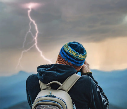
There is no storm photography territory in the world with a more established visual identity than the American Great Plains. The term "storm chasing" as most people imagine it was born here, and the images that defined the genre (rotating wall clouds, lightning-threaded supercell towers, bolts striking open prairie with no obstruction) all came from this corridor.
Tornado photography is the discipline within storm photography that the Plains have made their own. Nowhere else in the world do tornadoes form with the frequency, accessibility, and visual clarity that the Great Plains provides. A well-positioned photographer with a reliable weather model and a vehicle can realistically capture multiple tornado events in a single May week in central Oklahoma or south-central Kansas.
For tornado photography specifically, the visual conditions are extraordinary. The flat terrain means you can see a tornado from 20 to 40 miles away. The scale of the surrounding landscape, horizon to horizon with nothing interrupting the view, makes the tornado appear in complete context. Foreground elements like grain elevators, windmill farms, and long straight highways give scale reference that smaller, more wooded terrain cannot provide.
What Makes Plains Storm Photography Unique
Plains supercell thunderstorms are organized rotating storms with a defined visual architecture that exists nowhere else in the world in the same density. A mature supercell has identifiable, photographable components: the flat anvil top extending downwind, the rotating wall cloud lowering from the storm base, the rain-free base exposing the most dramatic storm structure, the clear slot of descending dry air wrapping around the mesocyclone, and the precipitation core behind it all.
None of this requires you to be inside or near the storm. The photographic sweet spot for Plains storm photography is 5 to 15 miles southeast of the supercell's direction of travel, outside the precipitation core and hail shaft, with a clear line of sight to the wall cloud and any tornado that may develop.
Peak Season: April Through June
-
April: The season opens in south Texas and Oklahoma. Late April can produce some of the year's most intense supercell events, though overall frequency is lower than May.
-
May: Peak season. The prime storm photography corridor shifts north through Oklahoma and into central and southern Kansas. This is when storm chasers from around the world converge on the region. Bolt rates are high, supercell frequency is at maximum, and tornado photography opportunities occur multiple times per week in active years. If you can do one Plains trip, this is the month.
-
June: Activity shifts further north into northern Kansas, Nebraska, and South Dakota. Storms mature later in the day and frequently coincide with golden hour: warm low-angle sun illuminating storm bases and rain shafts while lightning threads the cloud structure. June Plains images often produce the most color-rich results of the season.
-
July and beyond: The active zone shifts significantly northward. Kansas and Oklahoma quiet down considerably. Peak Plains photography season is largely May and June.
Where to Base Your Trip
-
Wichita, Kansas: Central location with easy access to both the Oklahoma border to the south and Nebraska to the north. Major airport, reliable lodging infrastructure for storm tourism season.
-
Oklahoma City, Oklahoma: Southern access point for the heart of Tornado Alley. The area within 100 miles in any direction produces some of the highest tornado frequency in the country.
-
North Platte, Nebraska: Northern access for June Plains photography, with the Nebraska Sandhills providing unusual and beautiful foreground variety for storm images.
The Primary Challenge
Hail is the most significant practical risk in Plains storm photography. Supercells routinely produce golf ball to baseball-sized hail in their precipitation cores. Never position yourself in or downwind of a storm core. The southeast quadrant of the storm, described above, is outside the primary hail threat. Keep a weather-sealed camera body or a quality rain sleeve on your gear at all times.
2. Florida: The Lightning Capital of the United States
Tampa Bay, the Gulf Coast, and the Atlantic Corridor
No state in the continental US produces more lightning than Florida, and no region within Florida produces more lightning than the Tampa Bay area. NOAA lightning density data consistently shows the I-4 corridor (Tampa to Orlando to the Atlantic coast) as the highest strike-density zone in the country, a result of daily sea breeze convergence between Gulf of Mexico and Atlantic moisture during summer months.
For lightning photography, this density is transformative. Instead of waiting hours for a single productive bolt, Florida summer sessions routinely produce dozens of bolt opportunities per evening. The statistical approach (long exposures at night) works reliably here because the storm rate is high enough that captures happen frequently. A triggered approach with the MIOPS Smart+ works especially well here because the high bolt rate keeps the trigger active throughout the session.
Peak Season: June Through September
-
June: The season opens as Gulf moisture builds. Afternoon storms develop by 2 to 4 PM and typically dissipate by evening, leaving clear-sky opportunities for night shooting after the session. First active month.
-
July and August: Peak. The convergence line fires nearly daily. Afternoon and early evening sessions become reliably productive. The combination of warm Gulf light and high bolt rates produces the best volume of the season.
-
September: Activity tapers but remains significant. September can produce some of the most dramatic individual storm events of the season as tropical moisture increases storm depth and intensity.
Positioning for Florida Lightning
-
Gulf Coast beaches: Wide sand flats with western exposure place you looking over open water toward Gulf-generating storms. Late afternoon and blue hour timing produces warm ambient light contrasting with electric bolt color.
-
St. Petersburg waterfront: Looking north toward Tampa across Tampa Bay, with city lights providing warm foreground against the storm structure above. One of the most accessible urban lightning foregrounds in the country.
-
Merritt Island and Canaveral area: The Atlantic coast storms develop differently from Gulf Coast systems, often producing more organized lines. The marshland of Merritt Island National Wildlife Refuge provides a natural, non-urban foreground.
The Primary Challenge
Storm speed and brevity. Florida afternoon storms move quickly and can dissipate in 30 to 45 minutes. Unlike Plains sessions where you can see a storm from 30 miles away and have 90 minutes to position, Florida storms require fast setup and flexible positioning. Have your settings pre-dialed before you reach your location.
3. Arizona and New Mexico: Desert Storm Photography
The North American Monsoon
Desert storm photography is its own visual genre within storm photography, and the American Southwest monsoon is where it reaches its peak. From roughly July 1 through mid-September, moisture from the Gulf of California and Gulf of Mexico flows into the high desert Southwest, generating afternoon convection over the mountains that moves into the valleys by late afternoon and evening.
The visual character of Southwest monsoon desert storm photography is immediately distinct from any other region. Lightning strikes over saguaro cactus forests. Bolt channels illuminate the red sandstone formations of the Sonoran Desert. Storm clouds build over the Rincon Mountains and the Santa Catalinas against a backdrop of desert terrain that has no photographic equivalent in the eastern US.
Peak Season: July Through Mid-September
-
July: The monsoon establishes in earnest around July 4 to 10 in most years. Early monsoon produces the strongest contrast between pre-monsoon drought conditions and arriving storm moisture: vivid colors, hard shadows, and dramatic first-week storms.
-
August: Peak monsoon. Storm frequency and intensity reach maximum. Evening lightning shows in the Phoenix basin and Tucson valleys occur 15 to 20 nights per month in active years.
-
Mid-September: Monsoon winds down. Storm frequency drops significantly after mid-month, though isolated events continue.
Location Specifics for Southwest Desert Storm Photography
-
Phoenix Basin (Maricopa County): South Mountain Park and the Estrella Mountain foothills provide elevated western vantage points looking over the city and open desert toward storm-prone terrain. The Phoenix city lights during monsoon storms produce the warm-vs-cool color contrast that drives strong images.
-
Tucson and Saguaro National Park: Both the east and west districts of Saguaro National Park place you in dense saguaro habitat within sight of the Rincon and Tucson mountains where storms frequently anchor. The saguaro cactus silhouette is the defining foreground element of Tucson desert storm photography.
-
Sedona and the Mogollon Rim: Red rock formations around Sedona photograph strikingly against monsoon storm structures. The Mogollon Rim above provides elevated vantage points with sweeping views across the Arizona high desert toward incoming storms.
-
White Sands, New Mexico: The gypsum dune landscape of White Sands during monsoon storms produces surreal, otherworldly desert storm photography. Access and timing require checking National Monument hours, but the visual result is like no other desert photography location.
The Primary Challenges
Flash flooding is the most significant safety issue in the Southwest monsoon. Desert soils do not absorb moisture quickly. Normally dry washes and canyon bottoms can fill with fast-moving water from rainfall miles away that you cannot see. Never position yourself in or near a wash or low-lying area during monsoon activity.
Haboobs (massive walls of airborne dust generated by storm outflow) are a secondary challenge and a separate photographic opportunity. When a haboob approaches, wrap your camera in a rain sleeve before the dust arrives and have a sealed vehicle ready.
4. Colorado: Alpine and Front Range Storm Photography
Rocky Mountain Afternoon Convection
Colorado's topography creates one of the most reliable afternoon storm cycles in the country. Solar heating over the mountains and high plains drives moisture-laden air upward each afternoon from June through August, producing thunderstorm development that is predictable enough to plan sessions around.
The visual character splits between two distinct environments. Alpine storm photography (bolts striking near or above treeline against high-elevation rock, conifer forest, and open tundra) produces images with an elevation drama that nothing at sea level can replicate. Front Range storm photography (storms building over the mountains as seen from the plains east of Denver) produces wide-angle compositions showing complete storm architecture against a mountain backdrop.
Peak Season: June Through August
-
June: The season opens with building convective energy. Afternoon storms develop by 1 to 3 PM over the high terrain. Lower crowds than July.
-
July: Peak convective season. Monsoon moisture from the south combines with strong solar heating to produce near-daily storm development. The most productive month for consistent Colorado storm photography.
-
August: Monsoon moisture deepens, bringing some of the most intense storm events. Afternoon storm timing is similar to July.
Safety Note for Colorado
Above treeline, you are the tallest object in the landscape. Above-treeline photography should be completed and you should be below treeline by noon at the latest. Shoot from mid-elevation positions (8,000 to 10,000 feet) that provide alpine foreground without placing you in the direct strike zone.
5. Texas: Two Peak Seasons, One State
Spring Plains and Gulf Coast
Texas is the most geographically diverse storm photography state in the US. The northern Panhandle catches the southern extension of Plains storm season. The Gulf Coast from Galveston to Corpus Christi produces Florida-style summer lightning over open water. West Texas and the Trans-Pecos region produce their own monsoon-adjacent convection from July through September.
The practical result is two distinct windows per year (spring and fall) with Gulf Coast activity bridging them through summer.
-
Spring (April to May): Supercell events in north Texas and the Panhandle comparable to Kansas and Oklahoma. Dallas, Lubbock, and Amarillo are primary bases.
-
Fall (September to October): A second wave of organized storm activity as Gulf moisture returns. Receives far less attention from photographers than spring, which means less competition and some surprisingly productive sessions.
6. Wyoming and Montana: The Uncrowded Northern Rockies
Greater Yellowstone and the Northern Plains
For photographers seeking dramatic storm and lightning images with minimal human presence, Wyoming and Montana offer a landscape scale and visual isolation that no other region can match. The Greater Yellowstone region, the Wyoming Range, and the Montana plains east of the Continental Divide all produce significant summer lightning during July and August in environments that remain largely undeveloped.
The foreground range spans volcanic plateau, open sagebrush basin, dense conifer forest, thermal geothermal features, and the wide-open cattle range of the Montana high plains. No other storm photography region offers this foreground diversity within a similar geographic radius.
Peak Season: July and August
The primary challenge in both states is limited road access in the most photogenic areas. Planning location access in advance, checking road conditions, and carrying appropriate emergency supplies for mountain terrain is essential.
US Storm Photography: Quick Reference Calendar
|
Month |
Primary Region |
What to Shoot |
|
April |
North Texas, southern Oklahoma |
Supercells, early tornado photography |
|
May |
Kansas, Oklahoma, Nebraska |
Tornado photography, supercell structure, Plains lightning |
|
June |
Central Plains, southern Colorado, early Florida |
Supercells, golden hour storms, first Florida sessions |
|
July |
Arizona monsoon, Florida, northern Colorado, Wyoming |
Desert storm photography, alpine lightning, high bolt-rate Florida sessions |
|
August |
Arizona monsoon peak, Florida, Montana, northern Rockies |
Desert storm photography peak, Northern Rockies lightning |
|
September |
Florida, Arizona winding down, Texas Gulf Coast |
Late-season Florida, Gulf Coast beach lightning |
|
October |
Texas Gulf Coast, isolated Plains events |
Second Texas window |
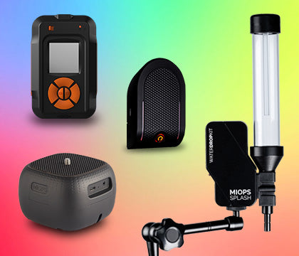
Field-Ready for Extended Location Shoots
Location-based storm photography demands more from your kit than a local session. Longer sessions, variable conditions, and the pressure of having traveled specifically for the shoot all point toward preparation that eliminates variables.
A lightning trigger becomes essential for location travel because the margin for missed opportunities is lower. You have invested time and travel to be at the best possible location during the best possible window. Manual timing at night works. Missing every bolt in a two-hour Golden Hour window in Tornado Alley because the timing did not align does not.
The MIOPS Smart Pro Pack is built for extended field sessions: the extended battery system handles multi-hour shoots, the longer cable gives mounting flexibility on a tripod, and the full trigger system means every qualifying bolt in your field of view is captured whether you are watching or not.
SEE WHAT THE MIOPS SMART+ CAN DOSound, laser, lightning, timelapse, HDR, and bulb ramping. One device. Compatible with Sony, Canon, Nikon, Fujifilm, and more. |
Frequently Asked Questions
Where is the best place in the US to photograph tornadoes?
The Oklahoma and Kansas corridor during May is the highest-frequency tornado photography territory in the world. The area bounded roughly by Oklahoma City to the south, Wichita to the north, and Dodge City to the west produces more photographable tornadoes per season than any comparable area globally. South Dakota's eastern prairie extends the zone northward into June.
What is the lightning capital of the US?
The Tampa Bay region of Florida consistently records the highest cloud-to-ground lightning density in the continental US according to NOAA data. The area receives more strikes per square mile per year than any other region, making it the most statistically reliable destination for lightning photography.
Do I need special equipment for storm photography in different regions?
Weather sealing becomes more important in the monsoon regions (dust and rain). A rain sleeve handles most precipitation scenarios. A lightning trigger becomes particularly valuable in the Plains, where sessions are longer and daytime lightning opportunities are more common than in Florida's night-friendly setup.
Is tornado photography safe?
Tornado photography at an appropriate distance (minimum 5 to 10 miles, with a clear exit route) is practiced by thousands of photographers and researchers each season. The risk comes from being too close, underestimating storm speed and direction change, or positioning in a location with no escape route. Mobile positioning and a reliable weather app are the primary safety tools.
Note: Storm season dates are based on NOAA climatological data for each region. Tornado density data references NOAA Storm Prediction Center historical records. Individual years vary significantly. Always check current forecasts before travel.


